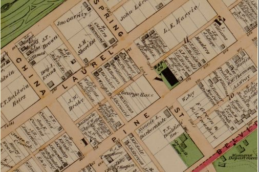
A very useful map for anyone studying the history of Oregon Hill and Richmond is the 1876 Beers Atlas. This very detailed atlas identifies the names of the property owners and shows the building footprints. For example, the detail above shows that the Baptist Church in 1876 was on the opposite corner of the 400 block of S. Pine Street, and that the Samuel Parsons House at 601 Spring Street was then known as the Spring Street Home. The Illustrated atlas of the city of Richmond, Va. / by F.W. Beers is available for free on the Library of Congress website (much of Oregon Hill is shown on Section P of the map): http://memory.loc.gov/
Photo credit: Library of Congress