Monument 10K Saturday – Lots of Road Closings in the Area

From Richmond Police:

The Richmond Police Department asks motorists to be mindful of runners, street closings and parking restrictions for the Ukrop’s Monument Avenue 10K this Saturday. The events begin at 8 a.m. on Saturday, April 13, with the Virginia 529 Kids Run. The first wave of the 10K steps off 8:30 a.m. near Broad and Harrison streets. The 10K’s finish line is on Franklin Street next to Monroe Park.

Logistics of the 10K will require numerous street closings and traffic pattern changes throughout the city beginning with parking restrictions starting at 1 p.m. on Friday, April 12. Restrictions and closures will continue until 3 p.m. on Saturday, April 13.

Richmond Police reminds all 10K event participants and attendees to take advantage of parking in the decks near the start and finish lines and to not leave any items that may tempt would-be thieves in plain view in your vehicle, regardless of where you park.

Continue reading

Traffic Advisory: Broad/Belvidere Land Closure On Sunday

From City announcement:

Lane Closure – Broad Street
WHO: City of Richmond Department of Public Works

WHAT: Lane Closure

WHEN: Sunday, March 10, 6 a.m. to 6 p.m.

WHERE: Broad Street at Belvidere Street

BACKGROUND: The left turn lanes at all approaches of the aforementioned intersection will be closed and left turn movements will be prohibited to allow for installation of fiber optic cables. Motorists are advised to seek alternate routes.

More Traffic Concerns About Harrison Street Intersection

More accidents at Harrison and Grayland have raised the call for more attention to the immediate area and its traffic concerns. From 8 News:

RICHMOND, VA—Changes are coming to a busy Richmond intersection after the 8News Street Squad took your concerns to the Department of Public Works.

Accidents are not uncommon at the intersection of Grayland Avenue and Harrison Street.

There were 14 crashes at the intersection from February 1, 2009 to February 1, 2013, according to the Richmond Department of Public Works.

After recognizing a pattern of “angle” type crashes at the intersection, the department said it will install “intersection ahead” signs on Harrison Street in both approaches.

Additionally, the following maintenance will be performed on the following traffic control devices:

-Replace two vandalized “no parking” signs on the west side of the bridge from Harrison Street southbound approaching Grayland Avenue.
-Replace a vandalized STOP sign on the south side of Grayland Ave.
-Install a stop bar on Grayland Ave.

Stay with 8News for updates.

This was also brought up at last night’s Oregon Hill Neighborhood Association meeting during a presentation by the City’s traffic engineering department. To that end, residents expressed solidarity with the Randolph neighborhood’s concerns.

Issue #5 comes to mind and the City traffic engineering has put the Idlewood roundabout concept forward in a proposed list of projects.


View Larger Map

A Cross-Section of the Canal

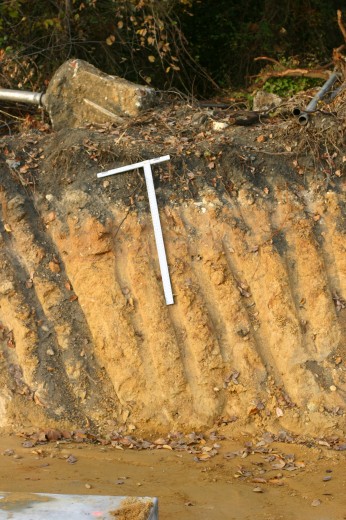
During the construction of the new bridge for the 2nd Street Connector, the contractors made a clean cut through the canal. This cut provided a cross-section of the canal.

As shown clearly in this photograph, there is only about a foot of dark top soil above the yellowish clay liner of the south bank of the canal. (photographer placed a 4 foot ruler in the photograph to show the scale.) Bill Trout, who is the former President of the American Canal Society, visited the site, and he took a sample of the clay and demonstrated how the clay was “puddled” with water to form an impervious barrier that kept the water from leaking from the canal.

This is important because Venture Richmond’s proposed plan to slice off 5-6 feet from the top of the south bank of the canal would definitely damage the integrity of the canal by slicing into the important clay liner of the canal.

City Council’s GRTC Task Force Meets Wednesday

From City press release:

Richmond City Council GRTC and Transit Study Task Force to hold meeting (NOTE New location and date)

All residents are invited and encouraged to attend

WHAT The Richmond City Council GRTC and Transit Study Task Force will hold a meeting. (NOTE: The location and date schedule of this meeting are different from previously held meetings.) The purpose of the Task Force is to make recommendations to Richmond City Council with regard to enhancing mass transit in the Metro-Richmond area and the efficiency and effectiveness of the GRTC Transit System. The meeting is free and open to the public and all residents are invited and encouraged to attend.
WHEN Wednesday, November 14, 2012
4:00-6:00 p.m.
WHERE Richmond Metropolitan Convention & Visitors Bureau Offices
401 North 3rd Street, 2nd floor – Richmond, Virginia 23219
Located inside the Greater Richmond Convention Center at the Corner of 3rd & Marshall Streets on the 2nd floor.
Parking is available in the Greater Richmond Convention Center parking garage located at 3rd & Marshall Streets. Once you have parked, exit the garage and cross Marshall Street. Enter the Exhibit Hall building at the corner of 3rd & Marshall Streets. Take elevator to the 2nd floor. The RMCVB’s offices are to the right.
WHO Members of the Richmond City Council GRTC and Transit Study Task Force
CONTACT For more information, please contact Marianne Pitts, at 804.646.5935;
or marianne.pitts@richmondgov.com.

Continue reading

Richmond Voice Covers Canal Wall Demolition

Thankfully, the Richmond Voice newspaper is still on the case. You can click here for the pdf of their recent issue, which includes a story about the recent destruction of the historic Kanawha canal wall.

Supposedly, the Police Dept and the Dept of Public Works are investigating the matter, but Oregon Hill residents remain concerned that it will not be fully prosecuted. Perhaps more outside pressure will come to bear.

On the Preservation of Richmond’s Canal

From email:

To all those interested in the future of Richmond’s historic canal:

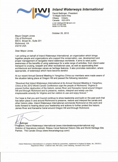
The attached letter is from Mr. D.J. Ballinger, president of the international canal organization Inland Waterways International, containing a resolution of support for the preservation and wise use of the remains of the James River & Kanawha Canal in Richmond. Originally known as the James River Canal, it was the first operating canal system with locks in America. It first opened in 1789 and was completed into the Great Basin in 1800. The canal company elected George Washington as its honorary president and gave him a grand tour in 1791. Today, much of the canal is still intact in Richmond.

The resolution was passed at the annual World Canals Conference, held this year in Yangzhou, China, on China’s Grand Canal. For 25 years these conferences have been held annually in America or Europe, and now, for the first time, in the far east. This one was held in conjunction with the Sixth World Canal Cities Expo, which has been held annually in Yangzhou. The Chinese are making the most of their canal heritage. Communities along its length are working together to nominate the Grand Canal as a World Heritage Site, and are using it to create beautiful parks and waterways much beloved by both tourists and those who live there. Efforts like this are going on all over the world.

Richmond rightly prides itself as a River Town and has learned much from other river cities. But Richmond is also a Canal City. The technology and philosophy of canal park development is not the same as river park development. We need to work not only with other river cities, but with other canal cities and canal parks to learn how we can put our historic canal to its best use for our city. The sweep of the canal around Oregon Hill is in danger and needs our help.

Bill Trout

Letters To The Editor

The Times Dispatch featured this letter about the new 2nd St. connector road, echoing concerns brought up by Oregon Hill residents as well as the local Sierra Club:

Connector road should have sidewalks

Editor, Times-Dispatch:

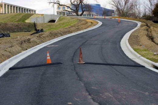
As I biked home recently and saw the Second Street connector road under construction, I pondered the design, which calls for two narrow travel lanes and a sidewalk on only one side of the road. This road will connect Second Street just north of the Lee Bridge to Tredegar Street and descends at an extremely steep grade.

The lack of an uphill bike lane and sidewalks will increase delays for motorists and compromise safety for everyone. This new road is in the middle of the city and immediately adjacent to Belle Isle, the Canal Walk and the James River Park System — some of the most popular places to walk, run and bike in the city. For even more evidence that a sidewalk on both sides of the street is needed, look no further than Tredegar Street itself, which lacks a sidewalk on the north side and has a worn dirt path there instead. Fixing this is one of the recommendations in the new Riverfront Plan. What about the thousands of pedestrians who descend this hill to attend the Folk Festival?

Dominion employees will probably have the most time to ponder the road design as they wait behind bicyclists traveling uphill at 5 mph, a problem that would have been easily avoided by adding a mere 5-foot bike lane. It is always more expensive to retrofit a road than to build new, so please, Richmond, let’s stop being pennywise and pound foolish.

John Bolecek.
Richmond.

Also, Oregon Hill resident Todd Woodson implored for a change of leadership in the 5th District:

Continue reading