SQUIRRELS!

Next time you see a squirrel in Monroe Park, you might want to consider their origin. A new paper in the Journal of American History covers The Urbanization of the Eastern Gray Squirrel in the United States:

The urbanization of the gray squirrel in the United States between the mid-nineteenth century and the early twentieth century was an ecological and cultural process that changed the squirrels’ ways of life, altered the urban landscape, and adjusted human understandings of nature, the city, and the boundaries of community.

Given the present ubiquity of gray squirrels, it may be difficult to believe that they have not always been common in American cities. In fact, they seem to have been entirely absent during the first half of the nineteenth century. The lack of systematic surveys before the twentieth century hinders estimates of the size of historical squirrel populations, which can fluctuate dramatically from year to year depending on food supplies, weather conditions, and other factors.

Canal Water Levels And Venture Richmond

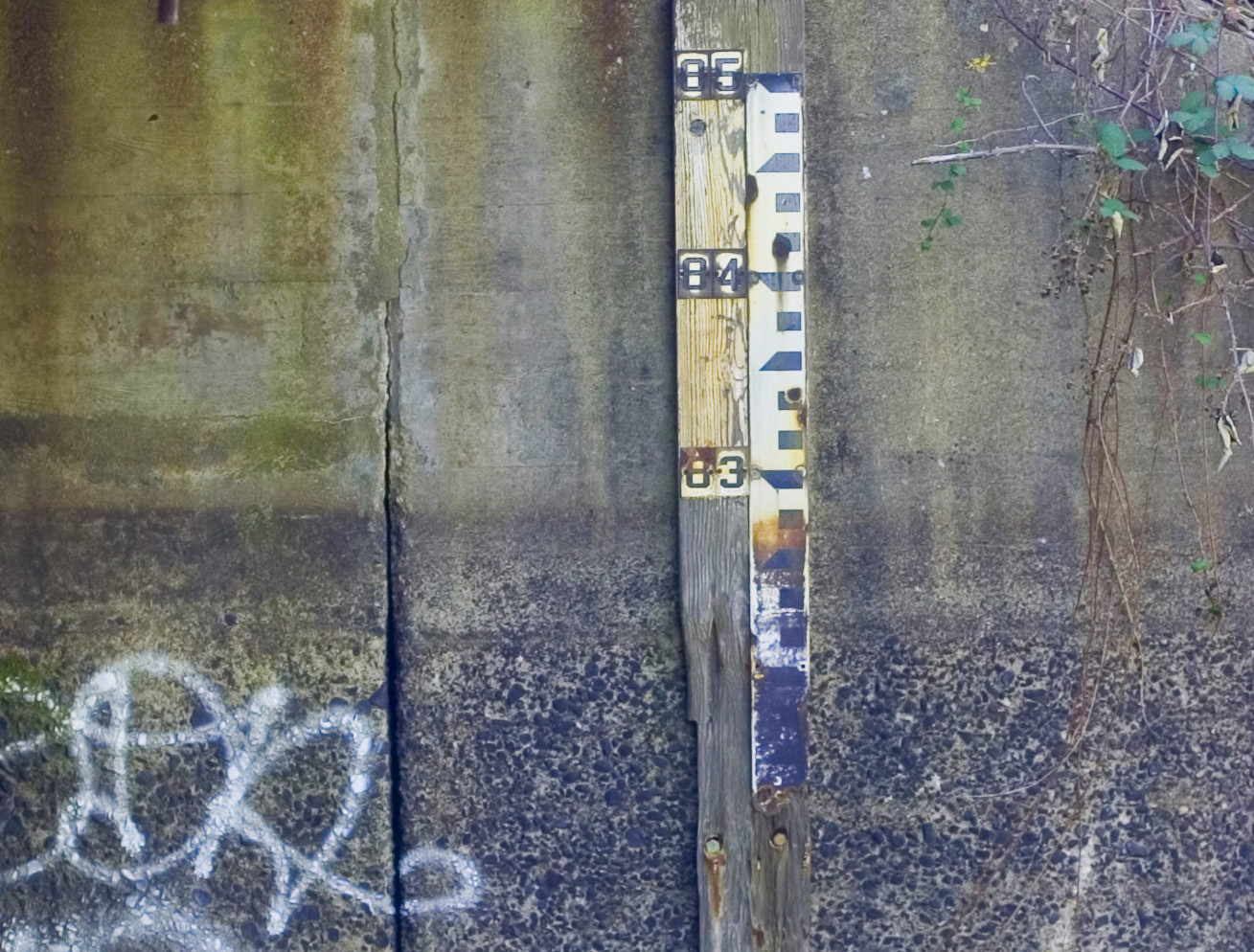
There is important new documentation on the water level in the James River and Kanawha Canal provided by the research of canal enthusiast C. Wayne Taylor. He has made the discovery that there is still a water gauge in the canal at the city Park Hydro near Cherry Street, some 1000 feet from Venture Richmond’s proposed amphitheater. The water level in the canal is clearly shown by a line on the wall at 83 feet next to this water gauge. Water has eroded all paint from the gauge under the 83 foot mark on the gauge.

James River and Kanawha Canal gauge at Park Hydro, Cherry Street, showing water line at 83 feet elevation

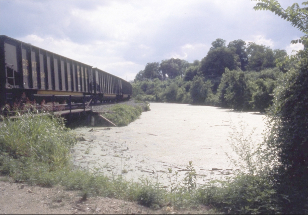
Remarkably, Wayne Taylor has also discovered a 1990s photograph from the City Planning Department in the VCU Library showing water in the canal at the location of the Park Hydro, and this photograph shows the water gauge in the canal.

Water in canal at 83 feet elevation at Cherry Street, Park Hydro, 1990s (Source - VCU Libraries)

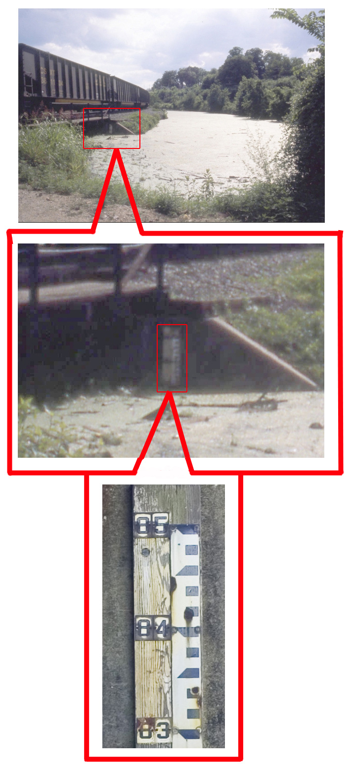
The 83 foot water elevation of the water in the canal shown in this gauge and photograph correspond with the many Tredegar and C&O Railroad surveys of the historical water level in the canal at this same location.

James River and Kanawha Canal detail showing 83 foot gauge at Park Hydro

It would be folly to reduce the elevation of the tow path of the James River and Kanawha Canal to 83 feet as proposed by Venture Richmond, when a preponderance of evidence shows that the historical water level in the canal near the amphitheater is documented at 83 feet elevation.

When will Venture Richmond acknowledge its plan is based on flawed history? When will Venture Richmond give in to sensible compromise and stop trying to dishonorably label neighborhood concerns as unreasonable?

Tredegar Takes In Museum of Confederacy To Form New Civil War Museum

It was alluded to earlier, but now it has been announced. From NBC12:

Now the Museum of the Confederacy and the American Civil War Center are joining forces to build a $30 million museum in Richmond with the goal of creating the top Civil War museum in the nation 150 years after the deadliest conflict fought on U.S. soil.

The marriage of museums, announced to The Associated Press, will meld the collection of Confederate battle flags, uniforms, weapons and other historic relics with a narrative-based museum that uses bold, interactive exhibits and living history events to relate its 360-degree telling of the war.

In a joint announcement, the museums said the new historic attraction in the former capital of the Confederacy has yet to be named, but $20 million has been committed to its construction. Ground will be broken in 2014, with an expected opening the following year.

The new museum will be located along the James River, at the Tredegar Ironworks, where much of the South’s cannons were forged during the war. It’s also the home of the Civil War Center. The museums said bringing together both institutions will “further establish Richmond as the foremost Civil War destination in the United States.”

While other news sites are just reporting the announcement, many are still digesting what this means. A more nuanced reflection from an unnamed Oregon Hill neighbor:

Hmmm … no comment on the fate of the authentic White House of the Confederacy, coveted by VCU. And the $20 million pledged for this new museum would have gone a long way toward building a slavery museum in the authentic location in Shockoe Bottom. I wonder what proportion of that $20 million is being pledged by VCU foundations and their donors.

Between turning the canal location into an amphitheater, turning the slave market location into a ball park, and ceding the White House of the Confederacy to VCU, we are really at risk of losing the city’s authentic history.

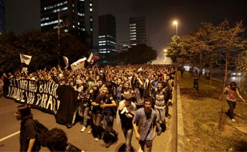
Uprisings in Brazil Event at WBCH On Saturday

From the Flying Brick’s website:

3a

We here at the Flying Brick Library are excited to be co-hosting this event with the William Byrd Community House!

When: November 17th, 7pm

Where: The William Byrd Community House, 224 S. Cherry St. in Oregon Hill

The June 2013 Uprisings in Brazil
A presentation by participants

Last summer, Brazil exploded in protests unlike anything in living memory. At the peak, a hundred cities participated in fierce clashes with the authorities; a movement that began with demonstrations against public transit fare increases and became a veritable popular uprising. Yet as the middle class joined in, nationalist
and reactionary narratives muddied the message.

Despite this, the movement succeeded in blocking the fare increases in many cities, demonstrating the effectiveness of new forms of struggle without parties or unions. Autonomous and horizontal groups forced other issues to the surface, including the consequences of the upcoming World Cup and Olympic games in Brazil.

In this presentation, Brazilian anarchists will describe the context from which the events of 2013 emerged, and explain their impact on other ongoing struggles. What conclusions are Brazilians drawing from their experiences, and what can North Americans learn from them?

For more background:
http://crimethinc.com/texts/recentfeatures/brazilpt1.php
http://crimethinc.com/texts/recentfeatures/brazilpt2.php

Facebook Event:

https://www.facebook.com/events/728696440492566/

Tredegar Holds Seance This Halloween

From the American Civil War Center website:

Spirit rapping, ghostly instruments, and other attempts at communion with the dead were once common occurrences in American parlors.

People from every social strata attended séances where mediums purported to be in contact with departed spirits. During the Civil War thousands desperate to contact fallen loved ones enlisted the aid of a medium. What would they have experienced at one of these sittings?

Find out at Historic Tredegar when we present a historically accurate séance inspired by the Spiritualist movement.

Join us October 28th – November 1st for this mysterious evening’s entertainment. Our story centers on Mr. and Mrs. Nelson as they seek to communicate to their son who lost his life during the Civil War.

Admission
$5

Click here to open the website and purchase online.

Remembering Slavery, Resistance, and Freedom Event Saturday

From the Remembering Slavery, Resistance, and Freedom Project:

October 12, 2013 – Community Conversation on African and African American Resistance to Slavery in Richmond, VA

On Saturday, October 12 from 10 AM – 12:30 PM at the William Byrd Community House, Ana Edwards will lead a presentation on two revolutionary African Americans, Gabriel and Lucy Goode Brooks. Following the presentation, Dr. Michael Blakey will facilitate an open dialogue and discussion. What are the stories of resistance that you know and would like to share? What modes of resistance or key figures would you like to learn more about? What do these histories mean to you?
Following a break for lunch after the discussion, Omilade Janine Bell of Elegba Folklore Society will lead a guided walk of the Trail of Enslaved Africans, beginning at 2:30 PM and ending at 6 PM.

The flyer for the event is available here. Because of space constraints, we ask attendees to RSVP through Facebook, email (remembering@wm.edu), or phone (757-221-7889).

Hopefully, Robert Pleasants and Samuel Parsons will be mentioned.

Harvie’s Deed Contradicts Venture Richmond’s Flawed History

New documentation from deed research that confirms that the 30 foot wide tow path on the site of Venture Richmond’s proposed amphitheater is authentic and dates from at least 1801.

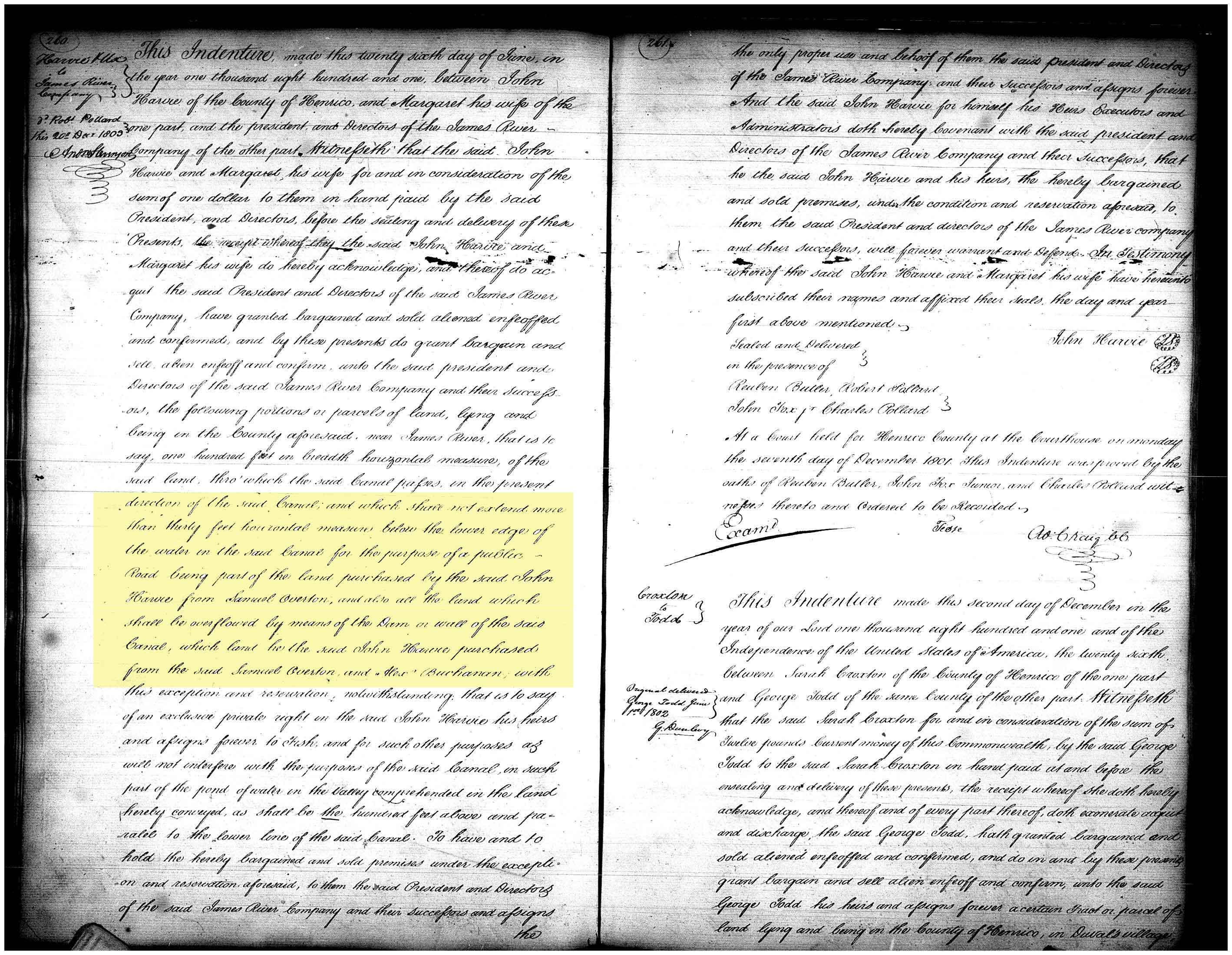
As documented in Henrico Deed Book 6, page 260, when John Harvie and his wife on June 26, 1801 conveyed to the James River Company his property for the canal and for the upper basin, he reserved the right to fish in the basin and reserved the condition of a “public Road” on the lower side of the canal not more than 30 feet wide from the edge of the water. In this deed, the tow path embankment was referenced as a “Dam” for holding back the water that was to overflow the upper basin.

In this 1801 deed, Harvie and his wife conveyed to the James River Company, “… the following portions or parcels of land, lying and being in the County aforesaid, near James River, that is to say one hundred feet in breadth horizontal measure, of the said land, thro’ which the said Canal passes in the present direction of the said Canal, and which shall not extend more than thirty feet horizontal measure below the lower edge of the water in the said canal for the purpose of a public Road being part of the land purchased by the said John Harris from Samuel Overton, and also all the land which shall be overflowed by means of the Dam or wall of the said Canal …” (Please see attachment, “Henrico DB 6, page 260.”)

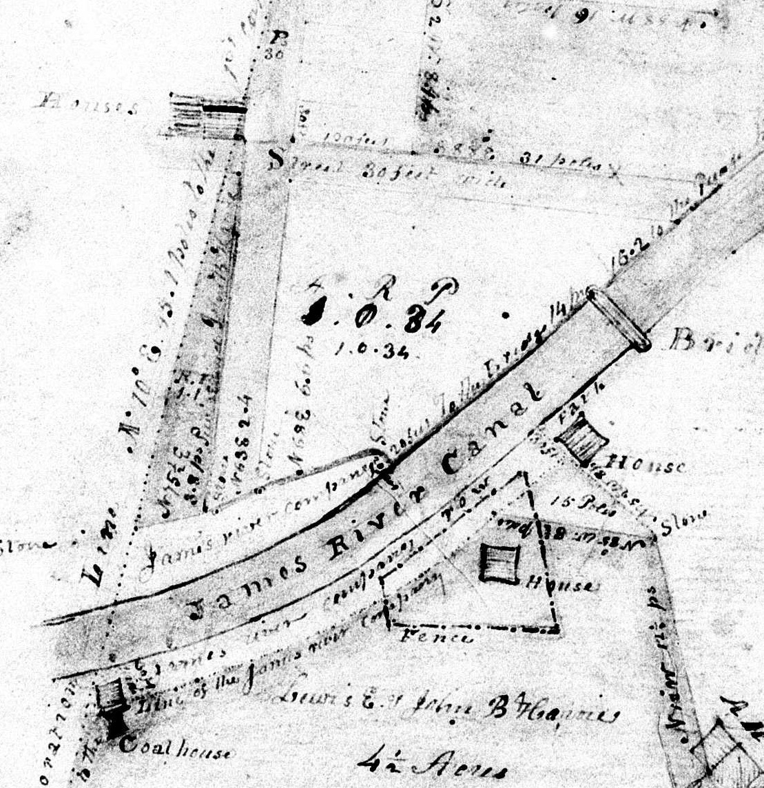
This 30 foot wide public access is clearly shown on the 1848 Plat of Harvie’s land. (Please see attachment, “Henrico Plat 3-417.”)
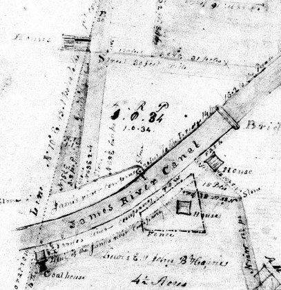
Henrico Plat 3-417 (crop)

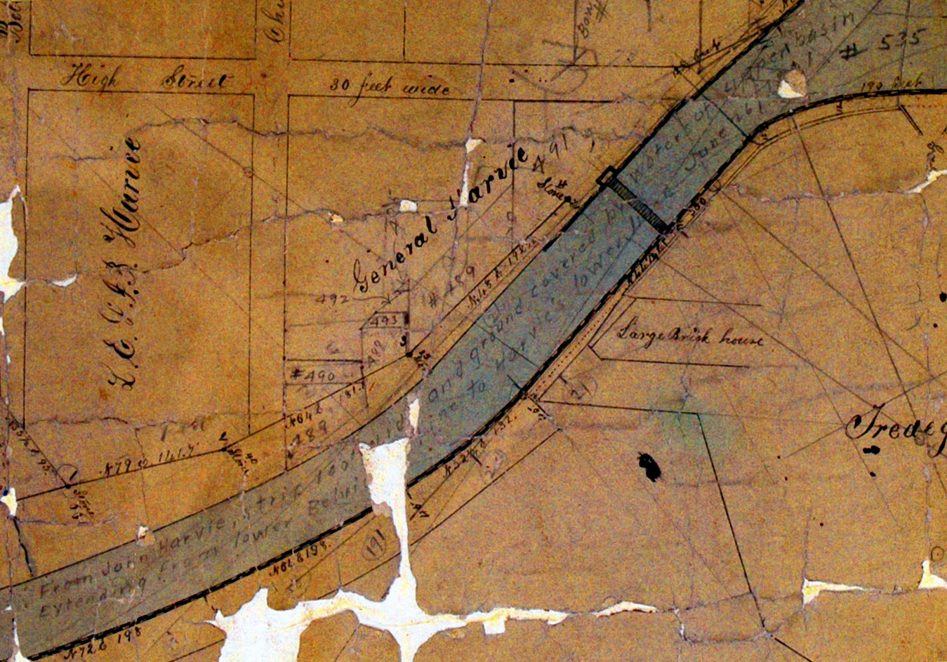
The 1868 Pleasants/Bates map, which shows the Canal company owning a 45 foot property width on the the south bank of the canal, has an inscription in the canal that references this June 26, 1801 Deed: “From John Harvie, strip 100′ wide and ground covered by water of upper basin … Extending from lower Belvidere line to Harvie’s lower line June 26, 1801” (Please see attachment, “1868 Pleasants/Bates map, detail showing 1801 Harvie deed reference.”)
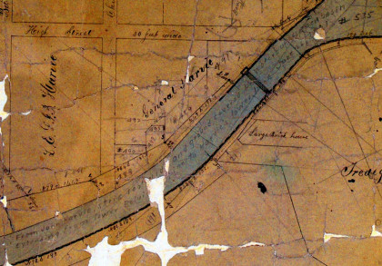
1868 Pleasants-Bates map, detail showing 1801 Harvie deed reference

As John Harvie recognized early on, by harnessing the water power available in the canal, there was great potential for industrial development on his land between the canal and the James River. He was a highly respected businessman, who not only was a Director of the James River Company and former Mayor of Richmond, but was one of the original statesmen in the Virginia delegation who ratified the U.S. Constitution. Harvie could command concessions in his sale of land to the James River Company that assured adequate access on the tow path for his industrial interests.

Hopefully, this new deed documentation will end the mistaken effort to alter the south bank of the canal from its authentic 1801 configuration for sight lines for the proposed amphitheater.
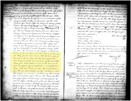

Henrico DB 6 p. 260, Harvie reserving 30 ft. road on south bank of canal

Hollywood Cemetery Stars

Richmond.com recently featured an article about Hollywood Cemetery that took a different approach from the usual “look at how many Presidents are buried here”-the author considers her favorite ‘stars’.

For example her “No. 3” is Mary Wingfield Scott:

Richmonders may not have been able to brag about the revitalization of Church Hill, because it almost got demolished. Preservationist Mary Wingfield Scott was instrumental in saving this neighborhood, as well as Oregon Hill and Linden Row. Thankfully, Richmond is known for its historic beauty, not an excess of Wal-Marts and giant parking lots.

FIRST ANNUAL REPORT OF THE PRESIDENT TO THE STOCKHOLDERS OF THE JAMES RIVER AND KANAWHA COMPANY, 1835

From the archives (ed. note: I did add the boldness to resolution 2):

FIRST ANNUAL REPORT
OF THE
PRESIDENT TO THE STOCKHOLDERS
OF THE
JAMES RIVER AND KANAWHA COMPANY,
TOGETHER WITH THE
PROCEEDINGS OF THE STOCKHOLDERS
At their first Annual Meeting in December 1835.
TO WHICH IS PREFIXED,
AN INTRODUCTION,
CONTAINING THE
PROCEEDINGS OF THE STOCKHOLDERS
At their first General Meeting, commencing on Monday the
25th of May, 1835.

page vii

TUESDAY, May 26th, 1835.
The stockholders met pursuant to adjournment.
Present as on yesterday, and stockholders and proxies representing
704 additional shares of stock.
Mr. Johnson, from the committee appointed on yesterday,
reported in part the following resolutions :
1. Resolved, That of the three plans of improvement specified
in the 22d section of the act, entitled, “an act incorporating
the stockholders of the James river and Kanawha com.
pany,” and by one or the other of which, to be selected at its
discretion, the company is charged with the duty of connecting
the tide water of James river with the navigable waters of
the Ohio, the stockholders deem it expedient and proper to
prefer, and do hereby elect, the first in the order of specification
set forth in said section; that is to say, “by a continuation
of the lower James river· canal to some suitable point on
the river not lower than Lynchburg, a continued rail-road
from the western termination of that canal to some convenient
point on the Great Kanawha river, below the great falls
thereof, and an improvement of the Kanawha river from
thence to the Ohio, so as to make it suitable for steam-boat
navigation.”
2. Resolved, That, with the exceptions herein after speci-
fied, the canal shall have a breadth at the bottom of not less
than 35 feet, and at the surface of not less than 50 feet, and
a depth of water of not less than 5 feet, with a suitable towpath
and guard-bank.

3. Resolved, That the breadth of the canal may, within
the minimum limit prescribed by the charter, be modified,
where local circumstances require it; and more especially in
the cases of deep cutting, steep side cutting, embanking, and
also where it is supported by walls; but a depth of 5 feet shall
be preserved throughout the line.